Import a GPX file

La Voie des Erables trails

Click on a trail to view its statistics, map and profile.
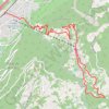
La Voie des Erables

Switzerland > Wallis > Martigny > Riddes

Cet itinéraire permet de découvrir Isérables, son histoire et son architecture en vous guidant à travers champs, forêts et rochers, entre barrières et passerelles.

Distance: 9.8 Km • Elevation gain: 993 m • Maximum elevation: 1,193 m

Gear up for your next adventure:

🧯Compact Fire Extinguishers - Safety for campervans and expedition vehicles
📸Travel Camera Tripods - Steady shots for landscape and long-exposure photos
🧥Gore-Tex Rain Jackets - Breathable and fully waterproof shells for Irish weather
🍖Freeze-Dried Trail Meals - Nutritious and lightweight food for expeditions
🛍️Outdoor Accessory Kits - Bundles for new hikers

As an Amazon Associate, this site earns from qualifying purchases at no extra cost to you.