Import a GPX file

Andrimont trails

Click on a trail to view its statistics, map and profile.
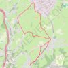
Ottomont - Andrimont - Mont Dison - Thimister - Andrimont - Ottomont

Belgium > Liège > Verviers > Dison > Andrimont

Monter jusqu'à l'église d'Andrimont, rejoindre Mont Dison par un chemin longeant les prairies. Rejoindre Thimister : Les Plenesses. Retour sur Andrimont via un chemin entre les prairies.

Distance: 9.9 Km • Elevation gain: 166 m • Maximum elevation: 295 m

Gear up for your next adventure:

🧥Waterproof Hiking Jackets - Rain jackets for unpredictable weather
🛸Lightweight Camera Drones - Capture stunning aerial topographic views of the landscape
🕶️Polarized Sunglasses - Reduce glare from lakes and sea cliffs
🧢Waterproof Caps - Keep rain off your face and glasses while hiking
🛶Waterproof Dry Bags - Keep electronics and clothes dry during wet treks

As an Amazon Associate, this site earns from qualifying purchases at no extra cost to you.