Import a GPX file

Randolph trails

Click on a trail to view its statistics, map and profile.
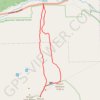
Mount Adams and Mount Madison Loop

United States > New Hampshire > Coos County > Randolph

Loop hike from Appalachia Trailhead to Mount Adams and Mount Madison via Airline Trail, Gulfside Trail, Madison Spring Hut, Osgood Trail, Watson Path and Valley Way in the Whites Mountains National Forest. #Hiking #Loop #Mountain #Nature #Forest

Distance: 13.8 Km • Elevation gain: 1,511 m • Maximum elevation: 1,754 m

Gear up for your next adventure:

🥾Women's Waterproof Boots - Gore-Tex protection for trail and mountain walking
🧺Quick-Dry Hiking Towels - Space-saving towels for wild swimming or camping
🪓Camping Axes & Hatchets - Wood cutting tools for campsite prep
👖Zip-off Hiking Pants - Adapt to changing Irish temperatures quickly
🔗Locking Carabiners - Secure gear to your pack or for light climbing

As an Amazon Associate, this site earns from qualifying purchases at no extra cost to you.