Import a GPX file

Cherbourg-en-Cotentin trails

Click on a trail to view its statistics, map and profile.
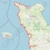
GR223 - Cherbourg à Coutances

France > Normandy > Manche > Cherbourg-en-Cotentin

https://en-hk.gps-viewer.com/track-217rr/GR223-Cherbourg-à-Coutances/

Distance: 201.4 Km • Elevation gain: 2,088 m • Maximum elevation: 138 m

Gear up for your next adventure:

🕶️Polarized Sunglasses - Reduce glare from lakes and sea cliffs
🚰Hydration Packs - Hands‑free water storage for hikers
🌧️Rain Gear for Hiking - Waterproof gear sets for wet hikes
🌦️Weatherproof Outdoor Gear - Protection from unpredictable weather
🪵Fire Starters & Tools - Tools to start fire in wet conditions

As an Amazon Associate, this site earns from qualifying purchases at no extra cost to you.