
Prescott trails
Click on a trail to view its statistics, map and profile.
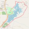
Watson Lake Loop
United States > Arizona > Yavapai County > Prescott
The Watson Lake Loop offers a scenic and diverse hiking experience with a variety of landscapes to enjoy. Hikers are treated to expansive views of Watson Lake, surrounded by unique rock formations known as the Granite Dells, and occasionally, a lush oasis near the Granite Creek Dam. The route features peaceful…
Distance: 7.5 Km • Elevation gain: 122 m • Maximum elevation: 1,600 m