Clausland Mountain County Park loop
- Distance: 6.6 Km
- Elevation gain: 173 m
- Maximum elevation: 200 m
- Elevation loss: 173 m
- Minimum elevation: 86 m
- Moving time: 1 h 23 m
- Moving speed: 4.7 Km/h
- Maximum speed: 11.1 Km/h
- Total time: 1 h 35 m
- Global speed: 4.1 Km/h
Interactive trail map
Trail profile
- Distance: 6.6 Km
- Elevation gain: 173 m
- Maximum elevation: 200 m
- Elevation loss: 173 m
- Minimum elevation: 86 m
- Moving time: 1 h 23 m
- Moving speed: 4.7 Km/h
- Maximum speed: 11.1 Km/h
- Total time: 1 h 35 m
- Global speed: 4.1 Km/h
About this trail
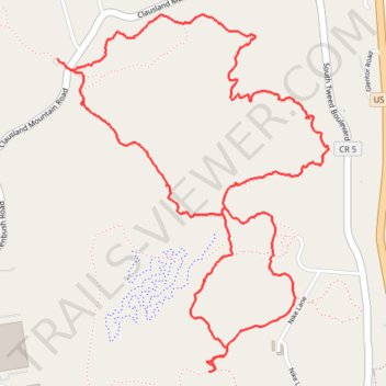
Name: Clausland Mountain County Park loop trail, distance, elevation, map, profile, GPS track
Coordinates: 41.05044 -73.93997 41.06437 -73.92595
Other hiking, mountain biking, running and outdoor activity trails
Click on a trail to view its statistics, map and profile.
Mount Nebo to Blauvelt State Park via Long Path Green Trail
United States > New York > Rockland County > Blauvelt
Distance: 19.1 Km • Elevation gain: 445 m • Maximum elevation: 200 m
Rail Trail Walk, Blauvelt Orangeburg
United States > New York > Rockland County > Village of Piermont
Distance: 12.8 Km • Elevation gain: 101 m • Maximum elevation: 60 m
Old Croton Aqueduct Trail and Bronx
United States > New York > Westchester County > Village of Croton-on-Hudson
Distance: 70.8 Km • Elevation gain: 823 m • Maximum elevation: 80 m
Nebo Clausland Tackamac Blauvelt
United States > New York > Rockland County > Orangeburg
Distance: 19.0 Km • Elevation gain: 478 m • Maximum elevation: 201 m
Blauvelt State Park
United States > New York > Rockland County > Blauvelt
Distance: 18.8 Km • Elevation gain: 434 m • Maximum elevation: 200 m