
Twin Falls and Sculpture Falls via Barton Creek Greenbelt Trail
The Barton Creek Greenbelt Trail offers a serene escape just minutes from downtown Austin. The path weaves through lush woods and alongside the creek, revealing scenic waterfalls such as the popular Twin Falls and the more secluded Sculpture Falls. While the terrain features occasional rocky sections, it’s generally manageable and rewards hikers with peaceful spots to relax by the water. This route is ideal for those seeking a mix of nature and tranquility. #Hiking #Waterfall #Forest #Nature
- Distance: 5.4 Km
- Elevation gain: 69 m
- Maximum elevation: 186 m
- Elevation loss: 69 m
- Minimum elevation: 169 m
- Moving time: 1 h 17 m
- Moving speed: 4.2 Km/h
- Maximum speed: 5.5 Km/h
- Total time: 1 h 17 m
- Global speed: 4.2 Km/h
Interactive trail map
Trail profile
- Distance: 5.4 Km
- Elevation gain: 69 m
- Maximum elevation: 186 m
- Elevation loss: 69 m
- Minimum elevation: 169 m
- Moving time: 1 h 17 m
- Moving speed: 4.2 Km/h
- Maximum speed: 5.5 Km/h
- Total time: 1 h 17 m
- Global speed: 4.2 Km/h
About this trail
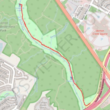
Name: Twin Falls and Sculpture Falls via Barton Creek Greenbelt Trail trail, distance, elevation, map, profile, GPS track
Coordinates: 30.24407 -97.82353 30.26191 -97.80911
Other hiking, mountain biking, running and outdoor activity trails
Click on a trail to view its statistics, map and profile.
Twin Falls and Sculpture Falls along Austin's Barton Creek Greenbelt Trail
United States > Texas > Travis County > Austin
The Twin Falls and Sculpture Falls hike is a perfect blend of rugged adventure and natural beauty. This out-and-back trail takes you through shady, tree-covered paths, with rocky sections and boulders that make it fun and moderately challenging. The highlight is reaching the serene waterfalls—Twin Falls and…
Distance: 5.2 Km • Elevation gain: 59 m • Maximum elevation: 186 m