Thank you for supporting this site ❤️
Make a donation
Make a donation
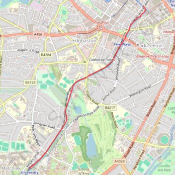
Birmingham Canal path walk to University
- Distance: 3.6 Km
- Elevation gain: 41 m
- Maximum elevation: 154 m
- Elevation loss: 38 m
- Minimum elevation: 137 m
- Moving time: 35 m 31 s
- Moving speed: 6.1 Km/h
- Maximum speed: 15.0 Km/h
- Total time: 35 m 31 s
- Global speed: 6.1 Km/h
Interactive trail map
Thank you for supporting this site ❤️
Make a donation
Make a donation
Trail profile
- Distance: 3.6 Km
- Elevation gain: 41 m
- Maximum elevation: 154 m
- Elevation loss: 38 m
- Minimum elevation: 137 m
- Moving time: 35 m 31 s
- Moving speed: 6.1 Km/h
- Maximum speed: 15.0 Km/h
- Total time: 35 m 31 s
- Global speed: 6.1 Km/h
Thank you for supporting this site ❤️
Make a donation
Make a donation
About this trail
Name: Birmingham Canal path walk to University trail, distance, elevation, map, profile, GPS track
Coordinates: 52.45146 -1.93631 52.47610 -1.90728
Thank you for supporting this site ❤️
Make a donation
Make a donation