Import a GPX file

Mirror Lake to Summit Peak

  • Distance: 3.7 Km
  • Elevation gain: 152 m
  • Maximum elevation: 590 m
  • Elevation loss: 55 m
  • Minimum elevation: 468 m
  • Moving time: 50 m 5 s
  • Moving speed: 4.4 Km/h
  • Maximum speed: 7.7 Km/h
  • Total time: 1 h 13 m
  • Global speed: 3.0 Km/h

Interactive trail map

Trail profile

  • Distance: 3.7 Km
  • Elevation gain: 152 m
  • Maximum elevation: 590 m
  • Elevation loss: 55 m
  • Minimum elevation: 468 m
  • Moving time: 50 m 5 s
  • Moving speed: 4.4 Km/h
  • Maximum speed: 7.7 Km/h
  • Total time: 1 h 13 m
  • Global speed: 3.0 Km/h

About this trail
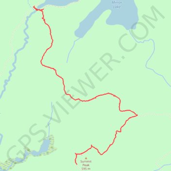
Name: Mirror Lake to Summit Peak trail, distance, elevation, map, profile, GPS track

Start: SML-1, South Mirror Lake Trail, Carp Lake Township, Ontonagon County, Michigan, United States (46.76093 -89.77863)

End: Summit Peak Trail, Carp Lake Township, Ontonagon County, Michigan, United States (46.74599 -89.77395)

Coordinates: 46.74599 -89.78004 46.76120 -89.76545

Gear up for your next adventure:

📸Travel Camera Tripods - Steady shots for landscape and long-exposure photos
🍴Camp Kitchen Kits - Lightweight nesting pots and pans for backpacking
📻Emergency Crank Radios - Stay informed in remote areas without power
🧼Biodegradable Soaps - Eco‑friendly soap for backpacking
🕶️Polarized Sunglasses - Reduce glare from lakes and sea cliffs

As an Amazon Associate, this site earns from qualifying purchases at no extra cost to you.