Abrams Falls Trail in Great Smoky Mountains National Park
Abrams Falls Trail in Great Smoky Mountains National Park offers hikers a journey through lush forests alongside the Abrams Creek. The trail features diverse terrain, including creek crossings on wooden bridges, leading to the impressive Abrams Falls, known for its powerful flow into a spacious natural pool. In the surrounding area, hikers can explore the historic Elijah Oliver Place, a preserved homestead reflecting the area's settler history. #Hiking #River #Forest #Nature #Waterfall
- Distance: 8.2 Km
- Elevation gain: 233 m
- Maximum elevation: 548 m
- Elevation loss: 234 m
- Minimum elevation: 465 m
- Moving time: 1 h 25 s
- Moving speed: 8.1 Km/h
- Maximum speed: 14.4 Km/h
- Total time: 1 h 45 m
- Global speed: 4.6 Km/h
Interactive trail map
Trail profile
- Distance: 8.2 Km
- Elevation gain: 233 m
- Maximum elevation: 548 m
- Elevation loss: 234 m
- Minimum elevation: 465 m
- Moving time: 1 h 25 s
- Moving speed: 8.1 Km/h
- Maximum speed: 14.4 Km/h
- Total time: 1 h 45 m
- Global speed: 4.6 Km/h
About this trail
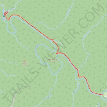
Name: Abrams Falls Trail in Great Smoky Mountains National Park trail, distance, elevation, map, profile, GPS track
Start: Abrams Falls Trail, Blount County, East Tennessee, Tennessee, United States (35.59132 -83.85277)
End: Abrams Falls Trail, Blount County, East Tennessee, Tennessee, United States (35.59133 -83.85269)
Coordinates: 35.59132 -83.87973 35.60986 -83.85269
Other hiking, mountain biking, running and outdoor activity trails
Click on a trail to view its statistics, map and profile.
Abrams Falls Trail in Great Smoky Mountains National Park
United States > Tennessee > Blount County
The Abrams Falls Trail is a moderate round-trip hike that begins near the Cades Cove Loop. The trail winds through pine-oak forests and alongside Abrams Creek, offering scenic views of hemlock trees and rhododendrons. Hikers will encounter rocky terrain and several footbridges, with the final reward being…
Distance: 8.5 Km • Elevation gain: 228 m • Maximum elevation: 551 m