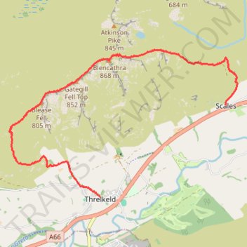
Blencathra hike
- Distance: 8.3 Km
- Elevation gain: 632 m
- Maximum elevation: 854 m
- Elevation loss: 713 m
- Minimum elevation: 159 m
- Moving time: 2 h 32 m
- Moving speed: 3.3 Km/h
- Maximum speed: 7.3 Km/h
- Total time: 3 h 37 m
- Global speed: 2.3 Km/h
Interactive trail map
Trail profile
- Distance: 8.3 Km
- Elevation gain: 632 m
- Maximum elevation: 854 m
- Elevation loss: 713 m
- Minimum elevation: 159 m
- Moving time: 2 h 32 m
- Moving speed: 3.3 Km/h
- Maximum speed: 7.3 Km/h
- Total time: 3 h 37 m
- Global speed: 2.3 Km/h
About this trail
Name: Blencathra hike trail, distance, elevation, map, profile, GPS track
Coordinates: 54.61930 -3.07593 54.64162 -3.01606
Other hiking, mountain biking, running and outdoor activity trails
Click on a trail to view its statistics, map and profile.
Blencathra, Knott and Skiddaw loop
United Kingdom > England > Cumberland > Keswick
Distance: 77.7 Km • Elevation gain: 4,362 m • Maximum elevation: 922 m
Blencathra and local peaks
United Kingdom > England > Westmorland and Furness > Scales > Guardhouse
Hike
Distance: 14.1 Km • Elevation gain: 873 m • Maximum elevation: 854 m