Thank you for supporting this site ❤️
Make a donation
Make a donation
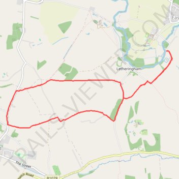
Letherningham Mill - Charsfield Circular
- Distance: 7.3 Km
- Elevation gain: 46 m
- Maximum elevation: 51 m
- Elevation loss: 47 m
- Minimum elevation: 17 m
- Moving time: 1 h 54 m
- Moving speed: 3.8 Km/h
- Maximum speed: 9.0 Km/h
- Total time: 2 h 6 s
- Global speed: 3.6 Km/h
Interactive trail map
Thank you for supporting this site ❤️
Make a donation
Make a donation
Trail profile
- Distance: 7.3 Km
- Elevation gain: 46 m
- Maximum elevation: 51 m
- Elevation loss: 47 m
- Minimum elevation: 17 m
- Moving time: 1 h 54 m
- Moving speed: 3.8 Km/h
- Maximum speed: 9.0 Km/h
- Total time: 2 h 6 s
- Global speed: 3.6 Km/h
Thank you for supporting this site ❤️
Make a donation
Make a donation
About this trail
Name: Letherningham Mill - Charsfield Circular trail, distance, elevation, map, profile, GPS track
Start: Letheringham, East Suffolk, Suffolk, England, IP13 7RE, United Kingdom (52.17471 1.33278)
End: Letheringham, East Suffolk, Suffolk, England, IP13 7RE, United Kingdom (52.17476 1.33276)
Coordinates: 52.16392 1.29624 52.17476 1.33407
Thank you for supporting this site ❤️
Make a donation
Make a donation