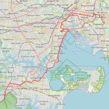
Bicycle ride from Maroubra to Loftus
- Distance: 33.8 Km
- Elevation gain: 276 m
- Maximum elevation: 112 m
- Elevation loss: 193 m
- Minimum elevation: -3 m
- Moving time: 1 h 54 m
- Moving speed: 17.8 Km/h
- Maximum speed: 34.0 Km/h
- Total time: 1 h 54 m
- Global speed: 17.7 Km/h
Interactive trail map
Trail profile
- Distance: 33.8 Km
- Elevation gain: 276 m
- Maximum elevation: 112 m
- Elevation loss: 193 m
- Minimum elevation: -3 m
- Moving time: 1 h 54 m
- Moving speed: 17.8 Km/h
- Maximum speed: 34.0 Km/h
- Total time: 1 h 54 m
- Global speed: 17.7 Km/h
About this trail
Name: Bicycle ride from Maroubra to Loftus trail, distance, elevation, map, profile, GPS track
Coordinates: -34.04552 151.05121 -33.92259 151.23172
Other hiking, mountain biking, running and outdoor activity trails
Click on a trail to view its statistics, map and profile.
Hike in the Royal National Park
Distance: 14.0 Km • Elevation gain: 354 m • Maximum elevation: 163 m
Sydney to Oran Park NSW
Australia > New South Wales > Sydney
Distance: 60.3 Km • Elevation gain: 577 m • Maximum elevation: 126 m
Cronulla Park
Australia > New South Wales > Sydney
Sydney Trail Run
Distance: 8.5 Km • Elevation gain: 85 m • Maximum elevation: 33 m