Footpath
- Distance: 0.4 Km
- Elevation gain: 2 m
- Maximum elevation: 3 m
- Elevation loss: 3 m
- Minimum elevation: 0 m
- Moving time: 4 m 26 s
- Moving speed: 5.3 Km/h
- Maximum speed: 6.6 Km/h
- Total time: 4 m 26 s
- Global speed: 5.3 Km/h
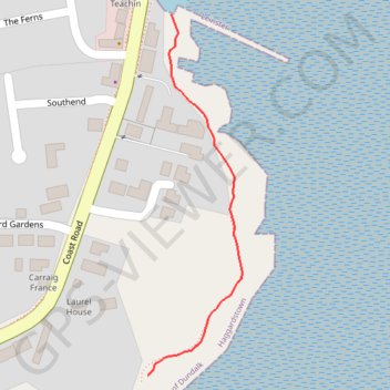
Interactive trail map
Trail profile
- Distance: 0.4 Km
- Elevation gain: 2 m
- Maximum elevation: 3 m
- Elevation loss: 3 m
- Minimum elevation: 0 m
- Moving time: 4 m 26 s
- Moving speed: 5.3 Km/h
- Maximum speed: 6.6 Km/h
- Total time: 4 m 26 s
- Global speed: 5.3 Km/h
About this trail
Name: Footpath trail, distance, elevation, map, profile, GPS track
Start: Haggardstown ED, Dundalk, County Louth, Leinster, A91 H9X3, Ireland (53.95765 -6.36711)
Coordinates: 53.95765 -6.36711 53.96057 -6.36581
Topography: County Louth topographic map, elevation, terrain