Import a GPX file

Mount Pleasant (Rising Park)

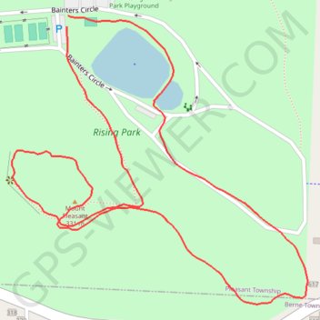
Loop hike to Mount Pleasant in Rising Park. #Hiking #Loop #Park #Forest #Nature

  • Distance: 1.8 Km
  • Elevation gain: 76 m
  • Maximum elevation: 318 m
  • Elevation loss: 76 m
  • Minimum elevation: 268 m
  • Moving time: 18 m 10 s
  • Moving speed: 6.1 Km/h
  • Maximum speed: 16.3 Km/h
  • Total time: 19 m 52 s
  • Global speed: 5.6 Km/h

Interactive trail map

Trail profile

  • Distance: 1.8 Km
  • Elevation gain: 76 m
  • Maximum elevation: 318 m
  • Elevation loss: 76 m
  • Minimum elevation: 268 m
  • Moving time: 18 m 10 s
  • Moving speed: 6.1 Km/h
  • Maximum speed: 16.3 Km/h
  • Total time: 19 m 52 s
  • Global speed: 5.6 Km/h

About this trail
Gear up for your next adventure:

🌲Bushcraft Skills Books - Learn navigation, fire-making, and shelter building
🧴Hiking Sunscreen - Sun protection for long exposure
📚Irish Walking Guides - The best mapped trails in Wicklow, Kerry, and Connemara
🧤Thermal Gloves - Warm gloves for cold weather
🧺Waterproof Picnic Blankets - Dry seating for breaks on damp grass

As an Amazon Associate, this site earns from qualifying purchases at no extra cost to you.