Thank you for supporting this site ❤️
Make a donation
Make a donation
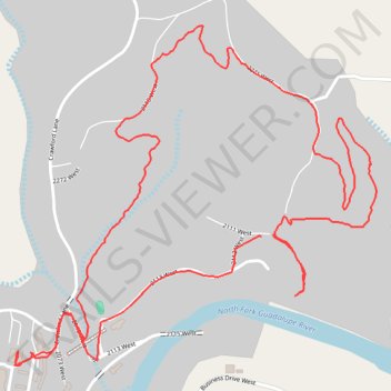
2026-04-11_16-05_Sat
- Distance: 5.4 Km
- Elevation gain: 109 m
- Maximum elevation: 639 m
- Elevation loss: 107 m
- Minimum elevation: 587 m
- Moving time: 1 h 22 m
- Moving speed: 3.9 Km/h
- Maximum speed: 27.9 Km/h
- Total time: 2 h 16 m
- Global speed: 2.4 Km/h
Interactive trail map
Thank you for supporting this site ❤️
Make a donation
Make a donation
Trail profile
- Distance: 5.4 Km
- Elevation gain: 109 m
- Maximum elevation: 639 m
- Elevation loss: 107 m
- Minimum elevation: 587 m
- Moving time: 1 h 22 m
- Moving speed: 3.9 Km/h
- Maximum speed: 27.9 Km/h
- Total time: 2 h 16 m
- Global speed: 2.4 Km/h
Thank you for supporting this site ❤️
Make a donation
Make a donation
About this trail
Name: 2026-04-11_16-05_Sat trail, distance, elevation, map, profile, GPS track
Start: 2111 West, Kerr County, Texas, United States (30.06561 -99.46499)
End: 2111 West, Kerr County, Texas, United States (30.06557 -99.46535)
Coordinates: 30.06207 -99.47306 30.07127 -99.46174
Thank you for supporting this site ❤️
Make a donation
Make a donation