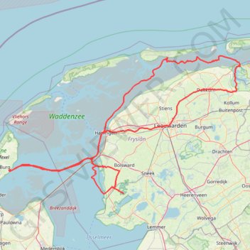
My Vessel Track
- Distance: 324.2 Km
- Elevation gain: 86 m
- Maximum elevation: 5 m
- Elevation loss: 88 m
- Minimum elevation: -4 m
- Moving time: 2 d 26 m
- Moving speed: 6.7 Km/h
- Maximum speed: 14.0 Km/h
- Total time: 17 d 23 h
- Global speed: 0.8 Km/h
Interactive trail map
Trail profile
- Distance: 324.2 Km
- Elevation gain: 86 m
- Maximum elevation: 5 m
- Elevation loss: 88 m
- Minimum elevation: -4 m
- Moving time: 2 d 26 m
- Moving speed: 6.7 Km/h
- Maximum speed: 14.0 Km/h
- Total time: 17 d 23 h
- Global speed: 0.8 Km/h
About this trail
Name: My Vessel Track trail, distance, elevation, map, profile, GPS track
End: Trekwei, Workum, Súdwest-Fryslân, Frisia, Netherlands, 8711 GS, Netherlands (52.98088 5.46663)
Coordinates: 52.95920 4.85404 53.44145 6.20287
Other hiking, mountain biking, running and outdoor activity trails
Click on a trail to view its statistics, map and profile.
Zwolle - Groningen
Netherlands > Overijssel > Zwolle
Distance: 98.6 Km • Elevation gain: 40 m • Maximum elevation: 18 m