
Castle Peak via Montezuma Basin Road and Castle Peak Trail in Maroon Bells–Snowmass Wilderness Area
The Castle Peak hike via Montezuma Basin Road offers a beautiful yet challenging journey through the heart of Colorado's Elk Mountains. Starting from the rugged Montezuma Basin Road, hikers are treated to panoramic views of alpine meadows, towering peaks, and remnants of mining history. Along the route, visitors can encounter a range of wildlife, including elk and marmots, while enjoying stunning vistas of nearby peaks like Conundrum and Malemute. #Hiking #Mountain #Nature
- Distance: 4.9 Km
- Elevation gain: 919 m
- Maximum elevation: 4,331 m
- Elevation loss: 0 m
- Minimum elevation: 3,411 m
Interactive trail map
Trail profile
- Distance: 4.9 Km
- Elevation gain: 919 m
- Maximum elevation: 4,331 m
- Elevation loss: 0 m
- Minimum elevation: 3,411 m
About this trail
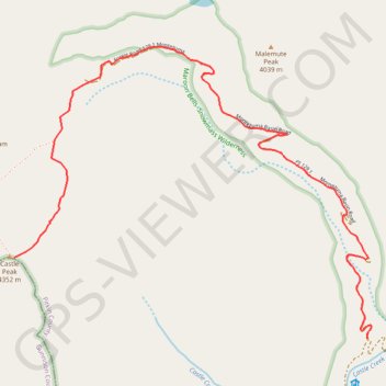
Name: Castle Peak via Montezuma Basin Road and Castle Peak Trail in Maroon Bells–Snowmass Wilderness Area trail, distance, elevation, map, profile, GPS track
Start: Montezuma Basin Road, Pitkin County, Colorado, United States (39.00553 -106.83820)
End: Castle Peak Trail, Pitkin County, Colorado, United States (39.00964 -106.86108)
Coordinates: 39.00553 -106.86108 39.02024 -106.83795