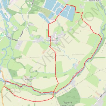
Northmoor - River Thames
- Distance: 12.6 Km
- Elevation gain: 30 m
- Maximum elevation: 69 m
- Elevation loss: 30 m
- Minimum elevation: 61 m
- Moving time: 3 h 16 m
- Moving speed: 3.8 Km/h
- Maximum speed: 7.4 Km/h
- Total time: 3 h 30 m
- Global speed: 3.6 Km/h
Interactive trail map
Trail profile
- Distance: 12.6 Km
- Elevation gain: 30 m
- Maximum elevation: 69 m
- Elevation loss: 30 m
- Minimum elevation: 61 m
- Moving time: 3 h 16 m
- Moving speed: 3.8 Km/h
- Maximum speed: 7.4 Km/h
- Total time: 3 h 30 m
- Global speed: 3.6 Km/h
About this trail
Name: Northmoor - River Thames trail, distance, elevation, map, profile, GPS track
Coordinates: 51.70379 -1.41771 51.73349 -1.36933
Other hiking, mountain biking, running and outdoor activity trails
Click on a trail to view its statistics, map and profile.
Dean2023-311
United Kingdom > England > Oxfordshire > Oxford
Distance: 310.3 Km • Elevation gain: 3,366 m • Maximum elevation: 290 m