
Morning Glory Bridge via Grandstaff Trail in Grandstaff Canyon Wilderness Study Area
The Morning Glory Bridge hike, accessed via the Grandstaff Trail in Moab's Negro Bill Canyon, offers an engaging blend of scenic views, geology, and historical significance. The trail follows a stream through the canyon, shaded by lush vegetation in parts, and leads to the striking natural arch. Along the way, hikers pass red rock formations, occasional pools perfect for a refreshing dip, and the occasional sound of water from the creek, with the reward being the impressive Morning Glory Arch, a grand feature that attracts climbers and adventurers. This relatively moderate hike is perfect for those seeking a mix of solitude, natural beauty, and a touch of history. #Hiking #Canyon #Desert #Nature
- Distance: 6.9 Km
- Elevation gain: 428 m
- Maximum elevation: 1,361 m
- Elevation loss: 428 m
- Minimum elevation: 1,222 m
Interactive trail map
Trail profile
- Distance: 6.9 Km
- Elevation gain: 428 m
- Maximum elevation: 1,361 m
- Elevation loss: 428 m
- Minimum elevation: 1,222 m
About this trail
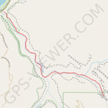
Name: Morning Glory Bridge via Grandstaff Trail in Grandstaff Canyon Wilderness Study Area trail, distance, elevation, map, profile, GPS track
Start: Grandstaff Trail, Grand County, Utah, 84532, United States (38.60984 -109.53355)
End: Grandstaff Trail, Grand County, Utah, 84532, United States (38.60984 -109.53355)
Coordinates: 38.59371 -109.53355 38.60985 -109.50879