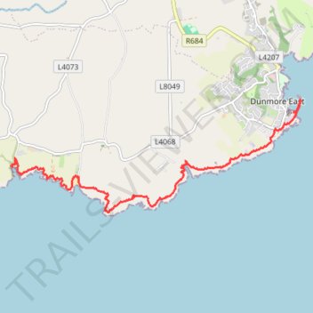
Ballymacaw and Dunmore East cliff walk
- Distance: 8.3 Km
- Elevation gain: 230 m
- Maximum elevation: 39 m
- Elevation loss: 228 m
- Minimum elevation: 0 m
- Moving time: 2 h 5 m
- Moving speed: 4.0 Km/h
- Maximum speed: 7.8 Km/h
- Total time: 2 h 19 m
- Global speed: 3.6 Km/h
Interactive trail map
Trail profile
- Distance: 8.3 Km
- Elevation gain: 230 m
- Maximum elevation: 39 m
- Elevation loss: 228 m
- Minimum elevation: 0 m
- Moving time: 2 h 5 m
- Moving speed: 4.0 Km/h
- Maximum speed: 7.8 Km/h
- Total time: 2 h 19 m
- Global speed: 3.6 Km/h
About this trail
Name: Ballymacaw and Dunmore East cliff walk trail, distance, elevation, map, profile, GPS track
Coordinates: 52.13296 -7.05645 52.14894 -6.98916
Topography: County Waterford topographic map, elevation, terrain