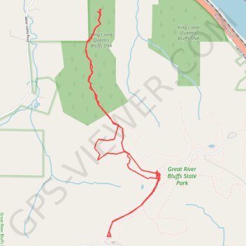
King's Bluff Overlook
Hike to King's Bluff Overlook via Park Road and King's Bluff Trail in the Great River Bluffs State Park and the King's and Queen's Bluffs Scientific and Natural Area. #Hiking #Nature #Forest #River #Park
- Distance: 6.4 Km
- Elevation gain: 110 m
- Maximum elevation: 393 m
- Elevation loss: 110 m
- Minimum elevation: 348 m
- Moving time: 1 h 34 m
- Moving speed: 4.1 Km/h
- Maximum speed: 39.3 Km/h
- Total time: 2 h 19 m
- Global speed: 2.7 Km/h
Interactive trail map
Trail profile
- Distance: 6.4 Km
- Elevation gain: 110 m
- Maximum elevation: 393 m
- Elevation loss: 110 m
- Minimum elevation: 348 m
- Moving time: 1 h 34 m
- Moving speed: 4.1 Km/h
- Maximum speed: 39.3 Km/h
- Total time: 2 h 19 m
- Global speed: 2.7 Km/h
About this trail
Name: King's Bluff Overlook trail, distance, elevation, map, profile, GPS track
Start: Map, Park Road, Winona County, Minnesota, 55925, United States (43.93959 -91.40832)
End: Park Road, Winona County, Minnesota, 55925, United States (43.93959 -91.40841)
Coordinates: 43.93955 -91.41110 43.95775 -91.40280