
Makahiku Falls and Waimoku Falls via Pīpīwai Trail (Maui Island)
Hike from Kipahulu Visitors Center to Makahiku Falls and Waimoku Falls via Pīpīwai Trail, Makahiku Overlook, Banyan Tree, Bamboo Forest, Kūloa Point Trail and Seven Sacred Pools in the Haleakalā National Park on Maui Island. #Hiking #Falls #Nature #Forest #Sea #Pacific #Ocean #Island #Hawaii #Park #River
- Distance: 6.4 Km
- Elevation gain: 332 m
- Maximum elevation: 334 m
- Elevation loss: 331 m
- Minimum elevation: 4 m
- Moving time: 3 h 11 m
- Moving speed: 2.0 Km/h
- Maximum speed: 8.3 Km/h
- Total time: 3 h 32 m
- Global speed: 1.8 Km/h
Interactive trail map
Trail profile
- Distance: 6.4 Km
- Elevation gain: 332 m
- Maximum elevation: 334 m
- Elevation loss: 331 m
- Minimum elevation: 4 m
- Moving time: 3 h 11 m
- Moving speed: 2.0 Km/h
- Maximum speed: 8.3 Km/h
- Total time: 3 h 32 m
- Global speed: 1.8 Km/h
About this trail
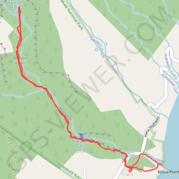
Name: Makahiku Falls and Waimoku Falls via Pīpīwai Trail (Maui Island) trail, distance, elevation, map, profile, GPS track
Start: Hana Highway, Kīpahulu, Maui County, Hawaii, United States (20.66188 -156.04459)
End: Hana Highway, Kīpahulu, Maui County, Hawaii, United States (20.66189 -156.04462)
Coordinates: 20.66188 -156.05675 20.67836 -156.04123