Import a GPX file

Durham Regional Forest Loop

Uxbridge Woodlands. #Hiking #MTB #Snowshoeing #Ski #Loop #Durham #Uxbridge

  • Distance: 10.0 Km
  • Elevation gain: 90 m
  • Maximum elevation: 377 m
  • Elevation loss: 90 m
  • Minimum elevation: 329 m

Interactive trail map

Trail profile

  • Distance: 10.0 Km
  • Elevation gain: 90 m
  • Maximum elevation: 377 m
  • Elevation loss: 90 m
  • Minimum elevation: 329 m

About this trail

Other hiking, mountain biking, running and outdoor activity trails

Click on a trail to view its statistics, map and profile.
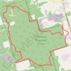
Durham Regional Forest - Uxbridge Trail

Canada > Ontario > Durham Region > Uxbridge

#Hiking #Loop #Durham

Distance: 9.5 Km • Elevation gain: 118 m • Maximum elevation: 400 m

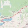
Québec - Montréal - Saint-Laurent River - Lake Ontario - Niagara Falls

Canada > Quebec > Urban agglomeration of Québec > Quebec

#Bike #Ontario

Distance: 1,078.4 Km • Elevation gain: 4,804 m • Maximum elevation: 209 m

Gear up for your next adventure:

🎒Backpack Rain Covers - Extra protection for non-waterproof rucksacks
📻Emergency Crank Radios - Stay informed in remote areas without power
🩹Compact First Aid Kits - Treat blisters and minor injuries on the trail
⛺Ultralight Hiking Tents - Compact shelters for multi-day wild camping in Ireland
🧴Long-Lasting Sunscreen - Protect against UV rays during long days on the ridges

As an Amazon Associate, this site earns from qualifying purchases at no extra cost to you.