Thank you for supporting this site ❤️
Make a donation
Make a donation
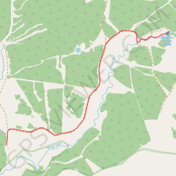
McCann Bothy
- Distance: 2.6 Km
- Elevation gain: 11 m
- Maximum elevation: 163 m
- Elevation loss: 120 m
- Minimum elevation: 53 m
- Moving time: 28 m 28 s
- Moving speed: 5.5 Km/h
- Maximum speed: 7.4 Km/h
- Total time: 28 m 28 s
- Global speed: 5.5 Km/h
Interactive trail map
Thank you for supporting this site ❤️
Make a donation
Make a donation
Trail profile
- Distance: 2.6 Km
- Elevation gain: 11 m
- Maximum elevation: 163 m
- Elevation loss: 120 m
- Minimum elevation: 53 m
- Moving time: 28 m 28 s
- Moving speed: 5.5 Km/h
- Maximum speed: 7.4 Km/h
- Total time: 28 m 28 s
- Global speed: 5.5 Km/h
Thank you for supporting this site ❤️
Make a donation
Make a donation
About this trail
Name: McCann Bothy trail, distance, elevation, map, profile, GPS track
Coordinates: 53.98502 -9.56090 53.99523 -9.53630
Topography: County Mayo topographic map, elevation, terrain
Thank you for supporting this site ❤️
Make a donation
Make a donation