Thank you for supporting this site ❤️
Make a donation
Make a donation
Tracked with OSMTracker for Android™
405
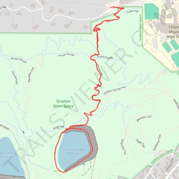
- Distance: 4.4 Km
- Elevation gain: 87 m
- Maximum elevation: 1,988 m
- Elevation loss: 85 m
- Minimum elevation: 1,936 m
- Moving time: 52 m 2 s
- Moving speed: 5.1 Km/h
- Maximum speed: 7.4 Km/h
- Total time: 56 m 57 s
- Global speed: 4.6 Km/h
Interactive trail map
Thank you for supporting this site ❤️
Make a donation
Make a donation
Trail profile
- Distance: 4.4 Km
- Elevation gain: 87 m
- Maximum elevation: 1,988 m
- Elevation loss: 85 m
- Minimum elevation: 1,936 m
- Moving time: 52 m 2 s
- Moving speed: 5.1 Km/h
- Maximum speed: 7.4 Km/h
- Total time: 56 m 57 s
- Global speed: 4.6 Km/h
Thank you for supporting this site ❤️
Make a donation
Make a donation
About this trail
Name: Tracked with OSMTracker for Android™ trail, distance, elevation, map, profile, GPS track
Coordinates: 38.79410 -104.86706 38.80451 -104.86142
Thank you for supporting this site ❤️
Make a donation
Make a donation