Thank you for supporting this site ❤️
Make a donation
Make a donation
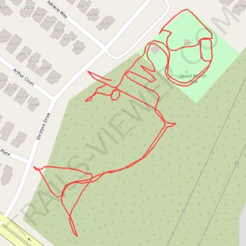
Lunch Walk
- Distance: 1.7 Km
- Elevation gain: 34 m
- Maximum elevation: 465 m
- Elevation loss: 34 m
- Minimum elevation: 441 m
- Moving time: 27 m 17 s
- Moving speed: 3.8 Km/h
- Maximum speed: 6.5 Km/h
- Total time: 31 m 4 s
- Global speed: 3.4 Km/h
Interactive trail map
Thank you for supporting this site ❤️
Make a donation
Make a donation
Trail profile
- Distance: 1.7 Km
- Elevation gain: 34 m
- Maximum elevation: 465 m
- Elevation loss: 34 m
- Minimum elevation: 441 m
- Moving time: 27 m 17 s
- Moving speed: 3.8 Km/h
- Maximum speed: 6.5 Km/h
- Total time: 31 m 4 s
- Global speed: 3.4 Km/h
Thank you for supporting this site ❤️
Make a donation
Make a donation
About this trail
Name: Lunch Walk trail, distance, elevation, map, profile, GPS track
Coordinates: 34.44743 -118.48963 34.45002 -118.48717
Thank you for supporting this site ❤️
Make a donation
Make a donation