Fall Creek Loop Trail via Cape Horn Trail in Henry Cowell Redwoods State Park
The Fall Creek Loop Trail via the Cape Horn Trail offers a captivating journey through the lush redwood forests of the Santa Cruz Mountains. Along the route, hikers will encounter the peaceful flow of Fall Creek, towering second-growth redwoods, and historic lime kilns that highlight the park's rich industrial history. The trail’s diverse landscape, including gentle slopes and serene creekside paths, provides a serene escape, with breathtaking views of moss-covered rocks and verdant vegetation filling the surrounding woods. #Hiking #Mountain #Forest #Nature #Loop #River
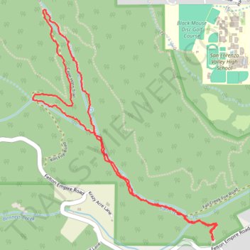
- Distance: 5.6 Km
- Elevation gain: 183 m
- Maximum elevation: 264 m
- Elevation loss: 183 m
- Minimum elevation: 145 m
- Moving time: 1 h 34 m
- Moving speed: 3.6 Km/h
- Maximum speed: 7.6 Km/h
- Total time: 1 h 40 m
- Global speed: 3.4 Km/h
Interactive trail map
Trail profile
- Distance: 5.6 Km
- Elevation gain: 183 m
- Maximum elevation: 264 m
- Elevation loss: 183 m
- Minimum elevation: 145 m
- Moving time: 1 h 34 m
- Moving speed: 3.6 Km/h
- Maximum speed: 7.6 Km/h
- Total time: 1 h 40 m
- Global speed: 3.4 Km/h
About this trail
Name: Fall Creek Loop Trail via Cape Horn Trail in Henry Cowell Redwoods State Park trail, distance, elevation, map, profile, GPS track
Start: Bennett Creek Trail, Santa Cruz County, California, 95018, United States (37.04981 -122.08315)
End: Bennett Creek Trail, Santa Cruz County, California, 95018, United States (37.04976 -122.08321)
Coordinates: 37.04976 -122.09766 37.06454 -122.08290