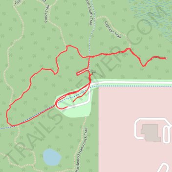
San Felasco Park: Cypress Overlook Trail
- Distance: 1.7 Km
- Elevation gain: 4 m
- Maximum elevation: 59 m
- Elevation loss: 4 m
- Minimum elevation: 55 m
- Moving time: 27 m 4 s
- Moving speed: 3.9 Km/h
- Maximum speed: 6.9 Km/h
- Total time: 29 m 8 s
- Global speed: 3.6 Km/h
Interactive trail map
Trail profile
- Distance: 1.7 Km
- Elevation gain: 4 m
- Maximum elevation: 59 m
- Elevation loss: 4 m
- Minimum elevation: 55 m
- Moving time: 27 m 4 s
- Moving speed: 3.9 Km/h
- Maximum speed: 6.9 Km/h
- Total time: 29 m 8 s
- Global speed: 3.6 Km/h
About this trail
Name: San Felasco Park: Cypress Overlook Trail trail, distance, elevation, map, profile, GPS track
Coordinates: 29.71199 -82.39433 29.71414 -82.38945