Make a donation
East Dorset Running
1:57:52 chip time. Wimborne St Giles as lovely as ever. Really nice sunny day, bit of breeze but mostly dappled shade anyway. Good fueling with 3-4 jelly babies every 5km. Great route. Took a tumble early on through the woods, no injury, fell pretty well with commando roll! Pleased with pace and overall running. (Edit- I was faster than same race last year) Do need stronger legs though! Rose entered first ever race, 200m got medal and bottle of water at the end. Lovely festival vibes- and injury/soreness I may have would be from the bouncy castle/slide with Rose! Massive portion of fully loaded fries afterwards.
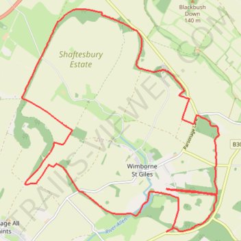
- Distance: 21.3 Km
- Elevation gain: 253 m
- Maximum elevation: 109 m
- Elevation loss: 253 m
- Minimum elevation: 47 m
- Moving time: 1 h 57 m
- Moving speed: 10.8 Km/h
- Maximum speed: 16.2 Km/h
- Total time: 1 h 57 m
- Global speed: 10.8 Km/h
Interactive trail map
Make a donation
Trail profile
- Distance: 21.3 Km
- Elevation gain: 253 m
- Maximum elevation: 109 m
- Elevation loss: 253 m
- Minimum elevation: 47 m
- Moving time: 1 h 57 m
- Moving speed: 10.8 Km/h
- Maximum speed: 16.2 Km/h
- Total time: 1 h 57 m
- Global speed: 10.8 Km/h
Make a donation
About this trail
Name: East Dorset Running trail, distance, elevation, map, profile, GPS track
Start: Wimborne St. Giles, Wimborne St Giles, Dorset, England, BH21 5NB, United Kingdom (50.90367 -1.95260)
End: Wimborne St. Giles, Wimborne St Giles, Dorset, England, BH21 5NB, United Kingdom (50.90360 -1.95243)
Coordinates: 50.89530 -1.99703 50.93865 -1.93631
Make a donation