Import a GPX file

גולני ירדנית

  • Distance: 48.3 Km
  • Elevation gain: 1,085 m
  • Maximum elevation: 393 m
  • Elevation loss: 1,511 m
  • Minimum elevation: -209 m

Interactive trail map

Trail profile

  • Distance: 48.3 Km
  • Elevation gain: 1,085 m
  • Maximum elevation: 393 m
  • Elevation loss: 1,511 m
  • Minimum elevation: -209 m

About this trail
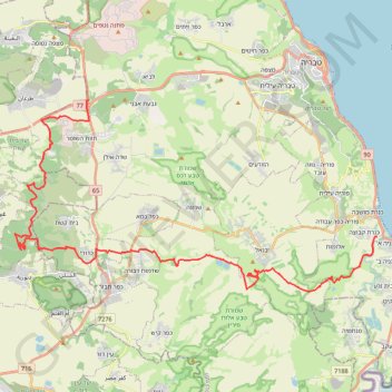
Name: גולני ירדנית trail, distance, elevation, map, profile, GPS track

Start: 77, Galil Tachton Regional Council, Kinneret Subdistrict, North District, 1529500, Israel (32.77604 35.40841)

End: Emek HaYarden Regional Council, Kinneret Subdistrict, North District, Israel (32.71147 35.57010)

Coordinates: 32.68527 35.36644 32.77604 35.57010

Gear up for your next adventure:

📱Phone Holders for Biking - Secure phone mounts for touring cyclists
🌦️Weatherproof Outdoor Gear - Protection from unpredictable weather
⛺Ultralight Hiking Tents - Compact shelters for multi-day wild camping in Ireland
🦯Lightweight Trekking Poles - Reduce knee strain on steep Wicklow or Kerry slopes
🎒Backpack Rain Covers - Extra protection for non-waterproof rucksacks

As an Amazon Associate, this site earns from qualifying purchases at no extra cost to you.