Red Rock Canyon
Chamberlain Trail
- Distance: 1.8 Km
- Elevation gain: 82 m
- Maximum elevation: 1,967 m
- Elevation loss: 17 m
- Minimum elevation: 1,896 m
- Moving time: 24 m 43 s
- Moving speed: 4.4 Km/h
- Maximum speed: 7.1 Km/h
- Total time: 25 m 20 s
- Global speed: 4.3 Km/h
Interactive trail map
Trail profile
- Distance: 1.8 Km
- Elevation gain: 82 m
- Maximum elevation: 1,967 m
- Elevation loss: 17 m
- Minimum elevation: 1,896 m
- Moving time: 24 m 43 s
- Moving speed: 4.4 Km/h
- Maximum speed: 7.1 Km/h
- Total time: 25 m 20 s
- Global speed: 4.3 Km/h
About this trail
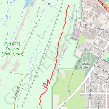
Name: Red Rock Canyon trail, distance, elevation, map, profile, GPS track
Start: Rim Trail, Colorado Springs, El Paso County, Colorado, 80904, United States (38.84836 -104.87514)
End: Rim Trail, Colorado Springs, El Paso County, Colorado, 80904, United States (38.83594 -104.87959)
Coordinates: 38.83594 -104.87961 38.84836 -104.87491
Other hiking, mountain biking, running and outdoor activity trails
Click on a trail to view its statistics, map and profile.
Mesa Trail, Greenlee Trail, and Red Rock Canyon Trail Loop in Red Rock Canyon Open Space
United States > Colorado > El Paso County > Colorado Springs
The Mesa, Greenlee, and Red Rock Canyon Trails Loop in Colorado Springs offers a pleasant hike through Red Rock Canyon Open Space, combining gentle inclines and peaceful scenery. The trail features expansive views of Garden of the Gods, a tranquil pond, and unique sandstone formations shaped by historic…
Distance: 2.9 Km • Elevation gain: 69 m • Maximum elevation: 1,941 m