Thank you for supporting this site ❤️
Make a donation
Make a donation
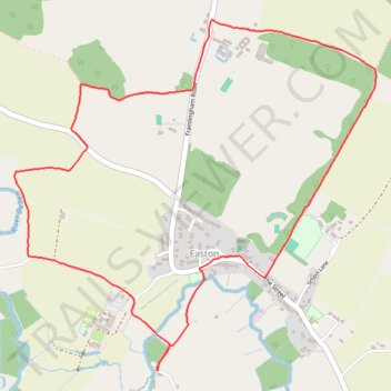
UK-LetheringhamMill-EastonParkCircular 1h38, 5.6km, 211m
- Distance: 5.5 Km
- Elevation gain: 38 m
- Maximum elevation: 44 m
- Elevation loss: 38 m
- Minimum elevation: 14 m
- Moving time: 1 h 29 m
- Moving speed: 3.7 Km/h
- Maximum speed: 5.8 Km/h
- Total time: 1 h 34 m
- Global speed: 3.5 Km/h
Interactive trail map
Thank you for supporting this site ❤️
Make a donation
Make a donation
Trail profile
- Distance: 5.5 Km
- Elevation gain: 38 m
- Maximum elevation: 44 m
- Elevation loss: 38 m
- Minimum elevation: 14 m
- Moving time: 1 h 29 m
- Moving speed: 3.7 Km/h
- Maximum speed: 5.8 Km/h
- Total time: 1 h 34 m
- Global speed: 3.5 Km/h
Thank you for supporting this site ❤️
Make a donation
Make a donation
About this trail
Name: UK-LetheringhamMill-EastonParkCircular 1h38, 5.6km, 211m trail, distance, elevation, map, profile, GPS track
Start: Letheringham, East Suffolk, Suffolk, England, IP13 7RE, United Kingdom (52.17476 1.33264)
End: Letheringham, East Suffolk, Suffolk, England, IP13 7RE, United Kingdom (52.17476 1.33268)
Coordinates: 52.17476 1.32348 52.18863 1.34677
Thank you for supporting this site ❤️
Make a donation
Make a donation