
Falls Branch Loop Trail in Lake Catherine State Park
The Falls Branch Loop Trail offers a picturesque hiking experience characterized by lush forests, charming wooden bridges, and a stunning waterfall. As you traverse the trail, you'll encounter a scenic overlook that provides breathtaking views of Lake Catherine, adding to the trail's beauty. This relatively short hike is accessible to various skill levels and is perfect for nature enthusiasts looking to relax and take in the serene surroundings. #Hiking #Loop #Waterfall #Forest #Lake #Nature
- Distance: 2.7 Km
- Elevation gain: 74 m
- Maximum elevation: 168 m
- Elevation loss: 74 m
- Minimum elevation: 103 m
- Moving time: 1 h 2 m
- Moving speed: 2.6 Km/h
- Maximum speed: 8.5 Km/h
- Total time: 1 h 19 m
- Global speed: 2.1 Km/h
Interactive trail map
Trail profile
- Distance: 2.7 Km
- Elevation gain: 74 m
- Maximum elevation: 168 m
- Elevation loss: 74 m
- Minimum elevation: 103 m
- Moving time: 1 h 2 m
- Moving speed: 2.6 Km/h
- Maximum speed: 8.5 Km/h
- Total time: 1 h 19 m
- Global speed: 2.1 Km/h
About this trail
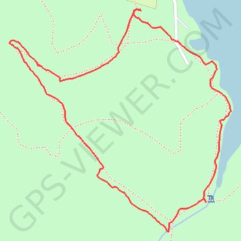
Name: Falls Branch Loop Trail in Lake Catherine State Park trail, distance, elevation, map, profile, GPS track
Start: Plum Hollow Boulevard, Hot Spring County, Arkansas, 71913, United States (34.43141 -92.91342)
End: Plum Hollow Boulevard, Hot Spring County, Arkansas, 71913, United States (34.43137 -92.91339)
Coordinates: 34.42453 -92.91833 34.43142 -92.91002