
Rome Point Loop Trail in John H. Chafee Nature Preserve
The Rome Point Loop Trail offers a serene hiking experience through lush coastal woodlands and salt marshes, leading to stunning views of Narragansett Bay. As you walk along the trail, you'll encounter diverse wildlife, including seasonal harbor seals, and enjoy the peaceful ambiance of the surrounding natural landscapes. This relatively easy route is perfect for families looking to explore the beauty of Rhode Island's coastline while engaging in activities like birdwatching and fishing in the nearby cove. #Hiking #Loop #Forest #Coast #Sea #Beach #Nature
- Distance: 4.1 Km
- Elevation gain: 28 m
- Maximum elevation: 18 m
- Elevation loss: 28 m
- Minimum elevation: -2 m
- Moving time: 48 m 23 s
- Moving speed: 5.1 Km/h
- Maximum speed: 17.9 Km/h
- Total time: 48 m 23 s
- Global speed: 5.1 Km/h
Interactive trail map
Trail profile
- Distance: 4.1 Km
- Elevation gain: 28 m
- Maximum elevation: 18 m
- Elevation loss: 28 m
- Minimum elevation: -2 m
- Moving time: 48 m 23 s
- Moving speed: 5.1 Km/h
- Maximum speed: 17.9 Km/h
- Total time: 48 m 23 s
- Global speed: 5.1 Km/h
About this trail
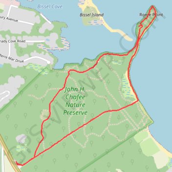
Name: Rome Point Loop Trail in John H. Chafee Nature Preserve trail, distance, elevation, map, profile, GPS track
Coordinates: 41.53700 -71.43735 41.54875 -71.42356