Import a GPX file

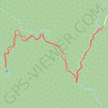
Montezuma Falls

#Hiking #Tasmania

  • Distance: 9.9 Km
  • Elevation gain: 487 m
  • Maximum elevation: 370 m
  • Elevation loss: 491 m
  • Minimum elevation: 255 m
  • Moving time: 1 h 52 m
  • Moving speed: 5.3 Km/h
  • Maximum speed: 17.5 Km/h
  • Total time: 1 h 53 m
  • Global speed: 5.2 Km/h

Interactive trail map

Trail profile

  • Distance: 9.9 Km
  • Elevation gain: 487 m
  • Maximum elevation: 370 m
  • Elevation loss: 491 m
  • Minimum elevation: 255 m
  • Moving time: 1 h 52 m
  • Moving speed: 5.3 Km/h
  • Maximum speed: 17.5 Km/h
  • Total time: 1 h 53 m
  • Global speed: 5.2 Km/h

About this trail
Gear up for your next adventure:

🗺️Irish Road Atlases - Comprehensive physical maps for road trips and navigation
🧭Sighting Compasses - Professional grade mirror compass for precise orientation
📦Outdoor Storage Bags - Keep gear organized and dry
🥛Insulated Flasks - Keep drinks hot or cold
🦯Lightweight Trekking Poles - Reduce knee strain on steep Wicklow or Kerry slopes

As an Amazon Associate, this site earns from qualifying purchases at no extra cost to you.