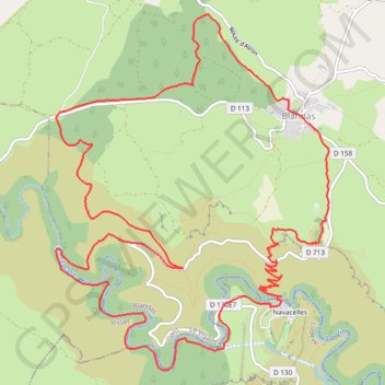
Espace Ceven'trail Circuit #1-10656957
- Distance: 17.1 Km
- Elevation gain: 628 m
- Maximum elevation: 737 m
- Elevation loss: 628 m
- Minimum elevation: 331 m
- Moving time: 2 h 7 m
- Moving speed: 8.0 Km/h
- Maximum speed: 11.2 Km/h
- Total time: 2 h 7 m
- Global speed: 8.0 Km/h
Interactive trail map
Trail profile
- Distance: 17.1 Km
- Elevation gain: 628 m
- Maximum elevation: 737 m
- Elevation loss: 628 m
- Minimum elevation: 331 m
- Moving time: 2 h 7 m
- Moving speed: 8.0 Km/h
- Maximum speed: 11.2 Km/h
- Total time: 2 h 7 m
- Global speed: 8.0 Km/h
About this trail
Name: Espace Ceven'trail Circuit #1-10656957 trail, distance, elevation, map, profile, GPS track
Coordinates: 43.88895 3.48266 43.92075 3.51653
Other hiking, mountain biking, running and outdoor activity trails
Click on a trail to view its statistics, map and profile.
PT23DS2 Lörrach → Cadaqués
Germany > Baden-Württemberg > Landkreis Lörrach > Lörrach (Kernstadt)
Distance: 1,050.7 Km • Elevation gain: 13,130 m • Maximum elevation: 1,505 m
Southern section — European Divide Trail
France > Auvergne-Rhône-Alpes > Drôme > Valence
Distance: 2,423.8 Km • Elevation gain: 42,375 m • Maximum elevation: 2,005 m
1 LUCENA - MONTPELLIER
Distance: 2,964.4 Km • Elevation gain: 29,500 m • Maximum elevation: 1,048 m
Chemin de Saint-Jacques-de-Compostelle
Switzerland > Geneva > Geneva
Distance: 1,117.8 Km • Elevation gain: 25,262 m • Maximum elevation: 1,430 m