Thank you for supporting this site ❤️
Make a donation
Make a donation
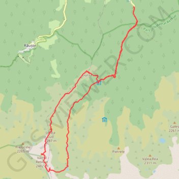
Carnic - vârful Retezat
- Distance: 21.2 Km
- Elevation gain: 1,603 m
- Maximum elevation: 2,475 m
- Elevation loss: 1,604 m
- Minimum elevation: 1,033 m
Interactive trail map
Thank you for supporting this site ❤️
Make a donation
Make a donation
Trail profile
- Distance: 21.2 Km
- Elevation gain: 1,603 m
- Maximum elevation: 2,475 m
- Elevation loss: 1,604 m
- Minimum elevation: 1,033 m
Thank you for supporting this site ❤️
Make a donation
Make a donation
About this trail
Name: Carnic - vârful Retezat trail, distance, elevation, map, profile, GPS track
Start: DJ667A, Sălașu de Sus, Hunedoara, 337423, Romania (45.43214 22.89508)
End: DJ667A, Sălașu de Sus, Hunedoara, 337423, Romania (45.43213 22.89515)
Coordinates: 45.37443 22.84924 45.43214 22.89698
Thank you for supporting this site ❤️
Make a donation
Make a donation
Other hiking, mountain biking, running and outdoor activity trails
Click on a trail to view its statistics, map and profile.
Carnic - Peleaga - Bucura1 - Retezat - Muntii Retezat
Romania > Hunedoara > Sălașu de Sus
Distance: 26.1 Km • Elevation gain: 2,027 m • Maximum elevation: 2,490 m
Carnic - Lacul Pietrele - vf. Peleaga - vf.Papusa - Portile ...
Romania > Hunedoara > Sălașu de Sus
Distance: 26.0 Km • Elevation gain: 1,955 m • Maximum elevation: 2,490 m
Vârful Retezat 2485m
Distance: 14.2 Km • Elevation gain: 1,303 m • Maximum elevation: 2,476 m