Import a GPX file

Taylors Beach walking tracks

  • Distance: 2.7 Km
  • Elevation gain: 34 m
  • Maximum elevation: 16 m
  • Elevation loss: 32 m
  • Minimum elevation: 0 m
  • Moving time: 48 m 12 s
  • Moving speed: 3.4 Km/h
  • Maximum speed: 7.1 Km/h
  • Total time: 57 m 9 s
  • Global speed: 2.9 Km/h

Interactive trail map

Trail profile

  • Distance: 2.7 Km
  • Elevation gain: 34 m
  • Maximum elevation: 16 m
  • Elevation loss: 32 m
  • Minimum elevation: 0 m
  • Moving time: 48 m 12 s
  • Moving speed: 3.4 Km/h
  • Maximum speed: 7.1 Km/h
  • Total time: 57 m 9 s
  • Global speed: 2.9 Km/h

About this trail
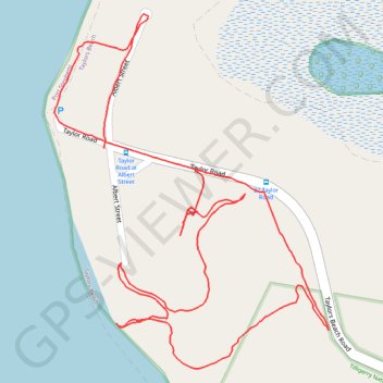
Name: Taylors Beach walking tracks trail, distance, elevation, map, profile, GPS track

Start: Taylor Road, Taylors Beach, Port Stephens Council, New South Wales, 2316, Australia (-32.73706 152.05629)

End: Taylor Road, Taylors Beach, Port Stephens Council, New South Wales, 2316, Australia (-32.73741 152.05794)

Coordinates: -32.74043 152.05539 -32.73502 152.06037

Gear up for your next adventure:

🧴Long-Lasting Sunscreen - Protect against UV rays during long days on the ridges
🪓Camping Hand Axes - For processing wood during forest camping
👣Orthopedic Boot Insoles - Extra comfort for long distance walking
👣Waterproof Leg Gaiters - Keep bog water and debris out of your boots
🕶️Polarized Sunglasses - Reduce glare from lakes and sea cliffs

As an Amazon Associate, this site earns from qualifying purchases at no extra cost to you.