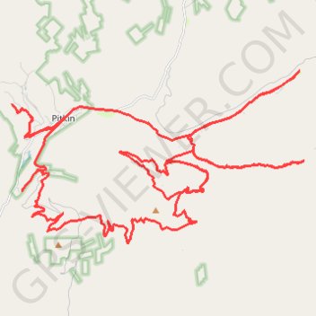
Pitkin Area Trails
- Distance: 66.7 Km
- Elevation gain: 1,886 m
- Maximum elevation: 3,407 m
- Elevation loss: 1,886 m
- Minimum elevation: 2,764 m
- Moving time: 3 h 44 m
- Moving speed: 17.9 Km/h
- Maximum speed: 52.8 Km/h
- Total time: 5 h 24 m
- Global speed: 12.3 Km/h
Interactive trail map
Trail profile
- Distance: 66.7 Km
- Elevation gain: 1,886 m
- Maximum elevation: 3,407 m
- Elevation loss: 1,886 m
- Minimum elevation: 2,764 m
- Moving time: 3 h 44 m
- Moving speed: 17.9 Km/h
- Maximum speed: 52.8 Km/h
- Total time: 5 h 24 m
- Global speed: 12.3 Km/h
About this trail
Name: Pitkin Area Trails trail, distance, elevation, map, profile, GPS track
Start: 441, Grasshopper Road, Gunnison County, Colorado, 81241, United States (38.61320 -106.53643)
End: 441, Grasshopper Road, Gunnison County, Colorado, 81241, United States (38.61322 -106.53646)
Coordinates: 38.57080 -106.53652 38.62316 -106.42325