Import a GPX file

Nordhouse Dunes Wilderness hike

  • Distance: 9.4 Km
  • Elevation gain: 106 m
  • Maximum elevation: 215 m
  • Elevation loss: 105 m
  • Minimum elevation: 177 m
  • Moving time: 3 h 11 m
  • Moving speed: 2.9 Km/h
  • Maximum speed: 11.8 Km/h
  • Total time: 3 h 59 m
  • Global speed: 2.4 Km/h

Interactive trail map

Trail profile

  • Distance: 9.4 Km
  • Elevation gain: 106 m
  • Maximum elevation: 215 m
  • Elevation loss: 105 m
  • Minimum elevation: 177 m
  • Moving time: 3 h 11 m
  • Moving speed: 2.9 Km/h
  • Maximum speed: 11.8 Km/h
  • Total time: 3 h 59 m
  • Global speed: 2.4 Km/h

About this trail
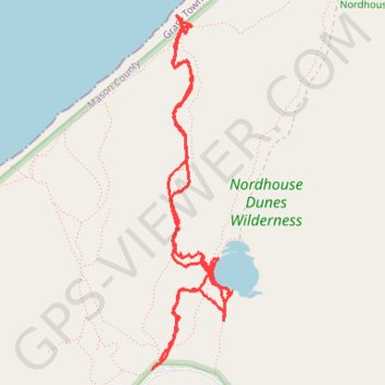
Name: Nordhouse Dunes Wilderness hike trail, distance, elevation, map, profile, GPS track

Start: West Nurnberg Road, Grant Township, Mason County, Michigan, 49431, United States (44.08714 -86.44507)

End: Nordhouse Dunes Beach M9-1, Grant Township, Mason County, Michigan, United States (44.08770 -86.44441)

Coordinates: 44.08714 -86.44516 44.10895 -86.43819

Gear up for your next adventure:

👣Orthopedic Boot Insoles - Extra comfort for long distance walking
🚰Hydration Packs - Hands‑free water storage for hikers
💡Hiking Headlamps - Hands‑free lights for night hikes
🔦High-Lumen Headlamps - Hands-free lighting for early starts or late finishes
🧦Merino Wool Socks - Moisture-wicking and blister-preventing trail socks

As an Amazon Associate, this site earns from qualifying purchases at no extra cost to you.