Import a GPX file

Bike Loop from Emlenton

#Bike #Loop #Road #Forest #Countryside #River #Nature

  • Distance: 73.8 Km
  • Elevation gain: 1,282 m
  • Maximum elevation: 476 m
  • Elevation loss: 1,278 m
  • Minimum elevation: 264 m

Interactive trail map

Trail profile

  • Distance: 73.8 Km
  • Elevation gain: 1,282 m
  • Maximum elevation: 476 m
  • Elevation loss: 1,278 m
  • Minimum elevation: 264 m

About this trail
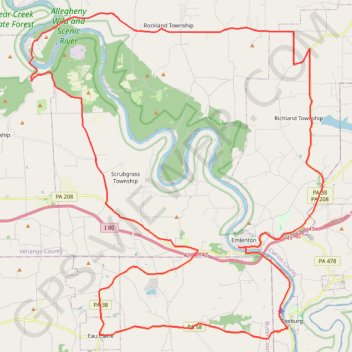
Name: Bike Loop from Emlenton trail, distance, elevation, map, profile, GPS track

Start: Emlenton, Venango County, Pennsylvania, 16373, United States (41.17730 -79.71279)

End: Emlenton Brew Haus, 610, Main Street, Emlenton, Venango County, Pennsylvania, 16373, United States (41.17715 -79.71066)

Coordinates: 41.13460 -79.84214 41.28608 -79.66056

Gear up for your next adventure:

🍖High-Protein Trail Snacks - Lightweight fuel for long distance treks
🥾Mountaineering Boots - Heavy‑duty boots for rugged peaks
🍖Freeze-Dried Trail Meals - Nutritious and lightweight food for expeditions
🔗Locking Carabiners - Secure gear to your pack or for light climbing
👖Zip-off Hiking Pants - Adapt to changing Irish temperatures quickly

As an Amazon Associate, this site earns from qualifying purchases at no extra cost to you.