Import a GPX file

West path Whatcom Falls south

  • Distance: 1.0 Km
  • Elevation gain: 16 m
  • Maximum elevation: 71 m
  • Elevation loss: 16 m
  • Minimum elevation: 56 m
  • Moving time: 16 m 22 s
  • Moving speed: 3.6 Km/h
  • Maximum speed: 5.8 Km/h
  • Total time: 16 m 22 s
  • Global speed: 3.6 Km/h

Interactive trail map

Trail profile

  • Distance: 1.0 Km
  • Elevation gain: 16 m
  • Maximum elevation: 71 m
  • Elevation loss: 16 m
  • Minimum elevation: 56 m
  • Moving time: 16 m 22 s
  • Moving speed: 3.6 Km/h
  • Maximum speed: 5.8 Km/h
  • Total time: 16 m 22 s
  • Global speed: 3.6 Km/h

About this trail
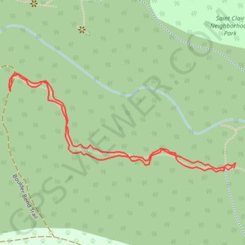
Name: West path Whatcom Falls south trail, distance, elevation, map, profile, GPS track

Start: Boulder Bend Trail, Roosevelt, Bellingham, Whatcom County, Washington, 98226, United States (48.75465 -122.43812)

End: Boulder Bend Trail, Roosevelt, Bellingham, Whatcom County, Washington, 98226, United States (48.75463 -122.43809)

Coordinates: 48.75458 -122.44272 48.75592 -122.43806

Gear up for your next adventure:

🌄Sun Protection Gear - Gear to shield from strong sun
🥽UV Protection Sunglasses - Protect eyes on bright days
🚶‍♂️Trekking Poles - Supportive poles for stability on varied terrain
🫗Collapsible Water Bottles - Space‑saving hydration
🎒Hiking Backpacks - Durable backpacks for day hikes and multi‑day treks

As an Amazon Associate, this site earns from qualifying purchases at no extra cost to you.