Import a GPX file

Valley of the 5 Lakes

Jasper National Park. #Hiking #Loop #Jasper

  • Distance: 19.4 Km
  • Elevation gain: 471 m
  • Maximum elevation: 1,167 m
  • Elevation loss: 476 m
  • Minimum elevation: 1,034 m

Interactive trail map

Trail profile

  • Distance: 19.4 Km
  • Elevation gain: 471 m
  • Maximum elevation: 1,167 m
  • Elevation loss: 476 m
  • Minimum elevation: 1,034 m

About this trail
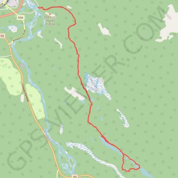
Name: Valley of the 5 Lakes trail, distance, elevation, map, profile, GPS track

Start: Valley of the 5 Lakes Trail, Municipality of Jasper, Alberta, T0E 1E0, Canada (52.87111 -118.06098)

End: Valley of the 5 Lakes Trail, Municipality of Jasper, Alberta, T0E 1E0, Canada (52.87134 -118.06226)

Coordinates: 52.81370 -118.06226 52.87158 -118.00303

Other hiking, mountain biking, running and outdoor activity trails

Click on a trail to view its statistics, map and profile.
Jasper - Jasper National Park

Canada > Alberta > Municipality of Jasper

#Bike #Jasper

Distance: 82.6 Km • Elevation gain: 942 m • Maximum elevation: 1,602 m

Gear up for your next adventure:

🧭Hiking Compasses - Reliable compasses for navigation off‑trail
🛶Waterproof Dry Bags - Keep electronics and clothes dry during wet treks
🦺Outdoor Safety Vests - Increase visibility and safety
🧤Touchscreen Glove Liners - Use your mapping app without freezing your hands
🏕️Camping Chairs - Comfortable outdoor chairs for campsites

As an Amazon Associate, this site earns from qualifying purchases at no extra cost to you.