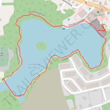
Old Mill Pond Trail around Lexington Mill Pond
- Distance: 2.0 Km
- Elevation gain: 17 m
- Maximum elevation: 95 m
- Elevation loss: 17 m
- Minimum elevation: 84 m
- Moving time: 32 m 15 s
- Moving speed: 3.8 Km/h
- Maximum speed: 7.3 Km/h
- Total time: 36 m 23 s
- Global speed: 3.4 Km/h
Interactive trail map
Trail profile
- Distance: 2.0 Km
- Elevation gain: 17 m
- Maximum elevation: 95 m
- Elevation loss: 17 m
- Minimum elevation: 84 m
- Moving time: 32 m 15 s
- Moving speed: 3.8 Km/h
- Maximum speed: 7.3 Km/h
- Total time: 36 m 23 s
- Global speed: 3.4 Km/h
About this trail
Name: Old Mill Pond Trail around Lexington Mill Pond trail, distance, elevation, map, profile, GPS track
Coordinates: 33.97346 -81.23476 33.97741 -81.22886
Other hiking, mountain biking, running and outdoor activity trails
Click on a trail to view its statistics, map and profile.
Old Mill Pond Trail loop
United States > South Carolina > Lexington County > Lexington
Evening Run
Distance: 5.7 Km • Elevation gain: 63 m • Maximum elevation: 96 m