Import a GPX file

Hammond Hill trails Y7 Y8

  • Distance: 7.5 Km
  • Elevation gain: 214 m
  • Maximum elevation: 602 m
  • Elevation loss: 214 m
  • Minimum elevation: 472 m
  • Moving time: 1 h 19 m
  • Moving speed: 5.6 Km/h
  • Maximum speed: 10.9 Km/h
  • Total time: 1 h 19 m
  • Global speed: 5.6 Km/h

Interactive trail map

Trail profile

  • Distance: 7.5 Km
  • Elevation gain: 214 m
  • Maximum elevation: 602 m
  • Elevation loss: 214 m
  • Minimum elevation: 472 m
  • Moving time: 1 h 19 m
  • Moving speed: 5.6 Km/h
  • Maximum speed: 10.9 Km/h
  • Total time: 1 h 19 m
  • Global speed: 5.6 Km/h

About this trail
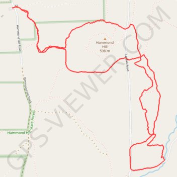
Name: Hammond Hill trails Y7 Y8 trail, distance, elevation, map, profile, GPS track

Start: Hammond Hill Road, Town of Dryden, Tompkins County, New York, 14817, United States (42.43715 -76.30575)

End: Hammond Hill Road, Town of Dryden, Tompkins County, New York, 14817, United States (42.43714 -76.30566)

Coordinates: 42.42257 -76.30575 42.43726 -76.28725

Gear up for your next adventure:

🛌Cold Weather Sleeping Bags - Warm sleeping bags for colder hikes
🪶Ultralight Tents - Lightweight shelters for hikers
📍Handheld GPS Devices - Accurate GPS units for mapping and navigation
🚰Hydration Packs - Hands‑free water storage for hikers
🦯Lightweight Trekking Poles - Reduce knee strain on steep Wicklow or Kerry slopes

As an Amazon Associate, this site earns from qualifying purchases at no extra cost to you.