Import a GPX file

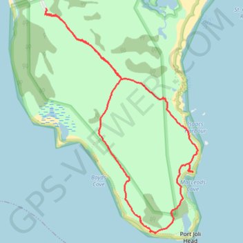
Port Joli Head Loop

#Hiking #Walking #Bike

  • Distance: 8.1 Km
  • Elevation gain: 56 m
  • Maximum elevation: 33 m
  • Elevation loss: 56 m
  • Minimum elevation: 0 m
  • Moving time: 1 h 39 m
  • Moving speed: 4.9 Km/h
  • Maximum speed: 9.6 Km/h
  • Total time: 1 h 47 m
  • Global speed: 4.5 Km/h

Interactive trail map

Trail profile

  • Distance: 8.1 Km
  • Elevation gain: 56 m
  • Maximum elevation: 33 m
  • Elevation loss: 56 m
  • Minimum elevation: 0 m
  • Moving time: 1 h 39 m
  • Moving speed: 4.9 Km/h
  • Maximum speed: 9.6 Km/h
  • Total time: 1 h 47 m
  • Global speed: 4.5 Km/h

About this trail
Gear up for your next adventure:

💺Camping Hammocks - Relax afloat camp setup
🦯Lightweight Trekking Poles - Reduce knee strain on steep Wicklow or Kerry slopes
🎒Day Packs - Perfect packs for day trips
🩴Trail Running Shoes - Fast, grippy shoes for trail runs
🔋Portable Power Banks - Keep devices charged on long trips

As an Amazon Associate, this site earns from qualifying purchases at no extra cost to you.