Thank you for supporting this site ❤️
Make a donation
Make a donation
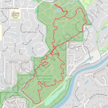
Sope Creek MTB Loop
Mountain Bike loop on Sope Creek Trails in Chattahoochee River National Recreation Area. #MTB #Loop #River #Forest #Nature
- Distance: 10.4 Km
- Elevation gain: 211 m
- Maximum elevation: 313 m
- Elevation loss: 211 m
- Minimum elevation: 252 m
- Moving time: 55 m 24 s
- Moving speed: 11.2 Km/h
- Maximum speed: 50.7 Km/h
- Total time: 55 m 24 s
- Global speed: 11.2 Km/h
Interactive trail map
Thank you for supporting this site ❤️
Make a donation
Make a donation
Trail profile
- Distance: 10.4 Km
- Elevation gain: 211 m
- Maximum elevation: 313 m
- Elevation loss: 211 m
- Minimum elevation: 252 m
- Moving time: 55 m 24 s
- Moving speed: 11.2 Km/h
- Maximum speed: 50.7 Km/h
- Total time: 55 m 24 s
- Global speed: 11.2 Km/h
Thank you for supporting this site ❤️
Make a donation
Make a donation
About this trail
Name: Sope Creek MTB Loop trail, distance, elevation, map, profile, GPS track
Start: Sope Creek, Sibley Forest, Cobb County, Georgia, 30000, United States (33.93787 -84.44253)
End: Sope Creek, Sibley Forest, Cobb County, Georgia, 30000, United States (33.93785 -84.44254)
Coordinates: 33.91601 -84.45136 33.93787 -84.43397
Thank you for supporting this site ❤️
Make a donation
Make a donation