Import a GPX file

Lake of the Woods Forest Preserve

  • Distance: 2.5 Km
  • Elevation gain: 20 m
  • Maximum elevation: 230 m
  • Elevation loss: 20 m
  • Minimum elevation: 211 m
  • Moving time: 53 m 5 s
  • Moving speed: 2.8 Km/h
  • Maximum speed: 4.6 Km/h
  • Total time: 1 h 5 m
  • Global speed: 2.3 Km/h

Interactive trail map

Trail profile

  • Distance: 2.5 Km
  • Elevation gain: 20 m
  • Maximum elevation: 230 m
  • Elevation loss: 20 m
  • Minimum elevation: 211 m
  • Moving time: 53 m 5 s
  • Moving speed: 2.8 Km/h
  • Maximum speed: 4.6 Km/h
  • Total time: 1 h 5 m
  • Global speed: 2.3 Km/h

About this trail
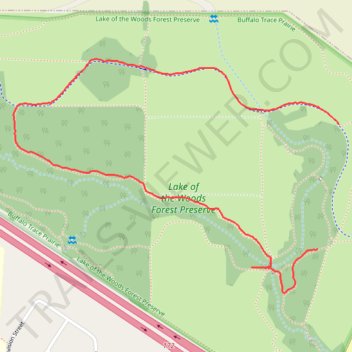
Name: Lake of the Woods Forest Preserve trail, distance, elevation, map, profile, GPS track

Start: County Road 350 East, Thornewood, Mahomet, Champaign County, Illinois, 61843, United States (40.20329 -88.39746)

End: County Road 350 East, Thornewood, Mahomet, Champaign County, Illinois, 61843, United States (40.20646 -88.39675)

Coordinates: 40.20216 -88.40761 40.20813 -88.39675

Gear up for your next adventure:

🪑Compact Camp Chairs - Comfortable seating after a long day of mapping
🔗Locking Carabiners - Secure gear to your pack or for light climbing
🌍Travel Adapters - Adapters for international travel
🩰Hiking Binoculars - See long distances on trails
🎒Surveyor High-Vis Vests - Multi-pocket safety vests for field professionals

As an Amazon Associate, this site earns from qualifying purchases at no extra cost to you.