Import a GPX file

Jack Smith Creek Wetlands Trail

  • Distance: 4.5 Km
  • Elevation gain: 12 m
  • Maximum elevation: 3 m
  • Elevation loss: 12 m
  • Minimum elevation: -3 m
  • Moving time: 57 m 24 s
  • Moving speed: 4.7 Km/h
  • Maximum speed: 8.1 Km/h
  • Total time: 58 m 8 s
  • Global speed: 4.7 Km/h

Interactive trail map

Trail profile

  • Distance: 4.5 Km
  • Elevation gain: 12 m
  • Maximum elevation: 3 m
  • Elevation loss: 12 m
  • Minimum elevation: -3 m
  • Moving time: 57 m 24 s
  • Moving speed: 4.7 Km/h
  • Maximum speed: 8.1 Km/h
  • Total time: 58 m 8 s
  • Global speed: 4.7 Km/h

About this trail
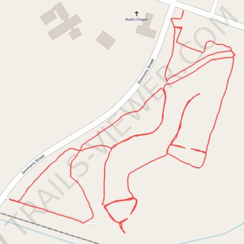
Name: Jack Smith Creek Wetlands Trail trail, distance, elevation, map, profile, GPS track

Start: Simmons Street, Woodrow, New Bern, Craven County, North Carolina, 28563, United States (35.12700 -77.06219)

End: 2679, Oaks Road, Woodrow, New Bern, Craven County, North Carolina, 28560, United States (35.12745 -77.06214)

Coordinates: 35.12194 -77.06741 35.12745 -77.06058

Gear up for your next adventure:

⌚Solar Multisport Watches - Advanced mapping and GPS tracking for endurance hikers
🛸Lightweight Camera Drones - Capture stunning aerial topographic views of the landscape
🛠️Tent Repair Kits - Fix tents on the trail
🧥Waterproof Hiking Jackets - Rain jackets for unpredictable weather
⌚Smart Watches for Hiking - Track performance on trails

As an Amazon Associate, this site earns from qualifying purchases at no extra cost to you.